Teknologi Visi Mesin
Teknologi reka bentuk laluan optik

Teknologi reka bentuk laluan optik terutamanya bertujuan untuk mengukur bahagian dengan bahan khas, Ciri -ciri kompleks, dan dimensi kecil. Apabila kesan imej sumber cahaya konvensional atau ruang struktur tidak dapat memenuhi keperluan pengukuran, Ia dapat menganalisis dan menilai secara mendalam berdasarkan ciri -ciri keperluan cahaya dan pengukuran, menjalankan reka bentuk struktur laluan optik khas, dapatkan kesan imej berkualiti tinggi, dan mencapai pengukuran ketepatan.
2D teknologi jahitan imej
2Teknologi jahitan imej D terutamanya bertujuan untuk pengukuran produk dalam bidang pandangan yang besar dan adegan berketepatan tinggi. Dengan mengumpul berbilang imej resolusi tinggi bahagian produk yang berbeza, titik ciri biasa diekstrak daripada setiap imej, dan matriks penjelmaan affine dibina; Gabungkan berbilang imej menjadi satu yang lancar, imej definisi tinggi melalui operasi matriks. Tidak seperti jahitan berasaskan rantau tradisional, teknologi ini menggabungkan prapemprosesan imej, pendaftaran, gabungan, dan teknik melicinkan sempadan untuk mencapai jahitan berketepatan tinggi berdasarkan ciri imej.
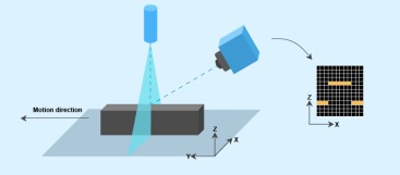
3D teknologi jahitan spatial imej
Teknologi jahitan spatial imej 3D terutamanya bertujuan untuk mengukur dimensi ruang 3D. Melalui transformasi matriks 3D, awan titik 3D berbilang diikat pada sistem koordinat spatial yang sama untuk membentuk model 3D sudut penuh. Syarikat itu telah mereka bentuk papan penentukuran berketepatan tinggi untuk imej jahitan berbilang muka, yang menggabungkan prapemprosesan imej, penyetempatan titik ciri, affine, dan teknologi gabungan imej untuk mencapai jahitan berketepatan tinggi.
2Teknologi penukaran sistem koordinat D dan 3D
1. Mengekstrak ciri objek yang sama secara serentak dalam ruang dua dimensi dan tiga dimensi, menggunakan teknik seperti putaran, penskalaan, dan unjuran untuk mendapatkan hubungan padanan antara ciri dua dimensi dan tiga dimensi, dan dengan itu mengira matriks transformasi antara sistem koordinat spatial dan planar.
2. Dengan menggabungkan garis laser dan kamera planar, teknologi menangkap ciri sudut melalui pengimejan 3D laser dan merakam ciri persisian pesawat melalui kamera planar disepadukan. Matriks penukaran antara sistem koordinat 3D dan 2D diperoleh melalui penentukuran, dan ciri-ciri dalam sistem koordinat 3D diunjurkan ke sistem koordinat 2D.